 wehub-resource-sync
7df9ebf22c
wehub-resource-sync
7df9ebf22c
Sync labels / sync (push) Failing after 1m9s
Publish Container Image / Build and publish container image (push) Has been cancelled
Deploy Website / Deploy to GitHub Pages (push) Has been cancelled
Deploy Website / Build website and demo (push) Has been cancelled
Deploy viewer / Deploy viewer proxy to Cloudflare Workers (push) Has been cancelled
Deploy tiles / Deploy planetary tile proxy to Cloudflare Workers (push) Has been cancelled
Deploy collab / Deploy collaboration relay to Cloudflare Workers (push) Has been cancelled
CI / Dependency audit (push) Has been cancelled
CI / E2E smoke (Playwright) (push) Has been cancelled
CI / Validate CITATION.cff (push) Has been cancelled
CI / Build and test (push) Has been cancelled
78 lines
4.5 KiB
Markdown
78 lines
4.5 KiB
Markdown
# SQL Workspace
|
|
|
|
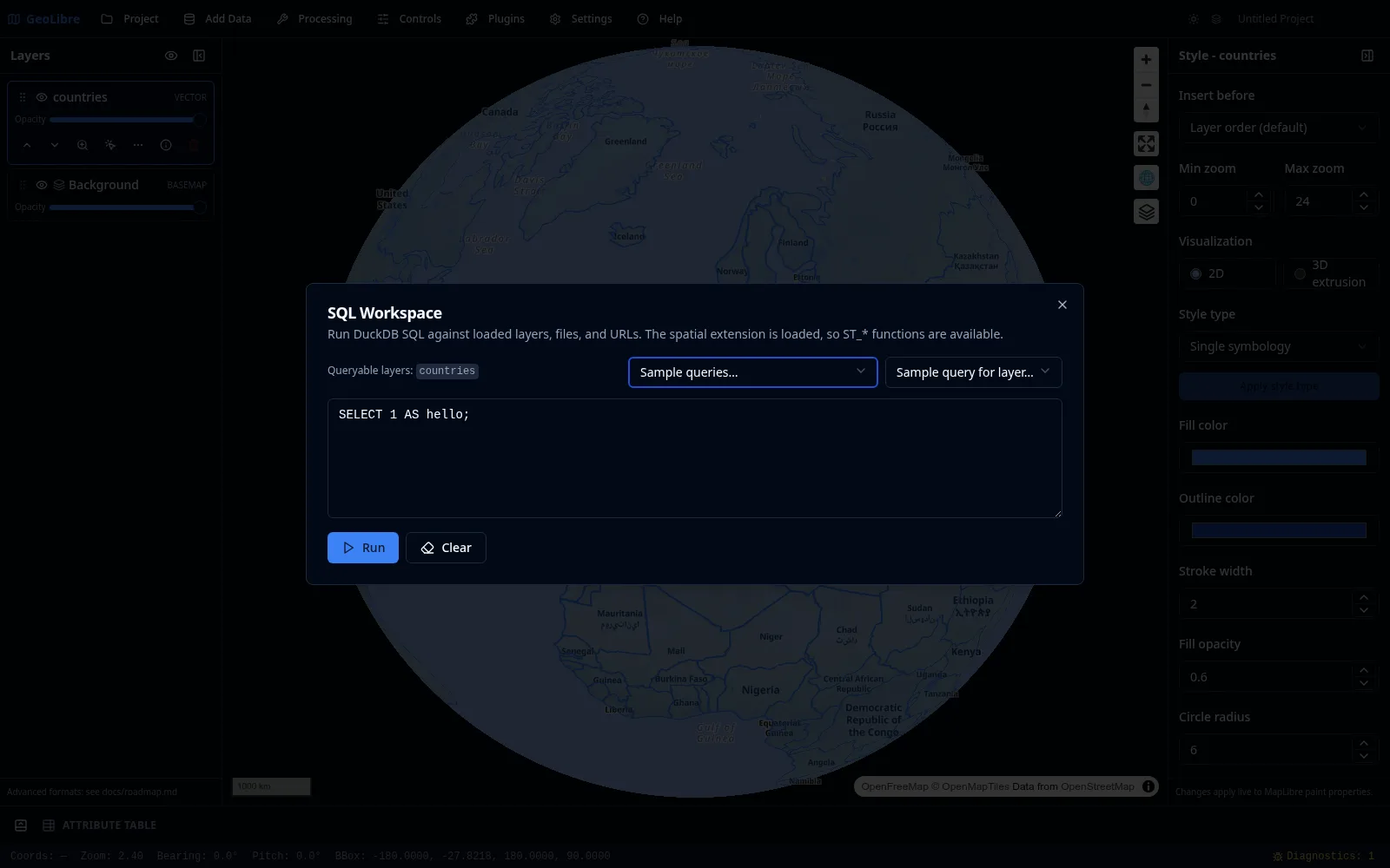
The **SQL Workspace** runs DuckDB Spatial SQL right in the app, against your loaded layers, local files, and remote URLs. Open it from **Processing → SQL Workspace**. The spatial extension is loaded for you, so `ST_*` functions are available.
|
|
|
|
|
|
|
|
## Querying loaded layers
|
|
|
|
Every loaded vector layer is exposed as a queryable table; the dialog lists the available table names at the top. Write a query in the editor and click **Run** to see the results.
|
|
|
|
```sql
|
|
SELECT NAME, CONTINENT, POP_EST
|
|
FROM countries
|
|
ORDER BY POP_EST DESC
|
|
LIMIT 10;
|
|
```
|
|
|
|
## Reading files and URLs
|
|
|
|
You can query files and remote URLs directly. The workspace auto-wraps a bare URL into the matching reader (for example Parquet, CSV, JSON, or GeoJSON) and streams remote files over HTTP range requests, so you do not have to download them first.
|
|
|
|
```sql
|
|
SELECT NAME, CONTINENT, POP_EST, geom
|
|
FROM https://data.source.coop/giswqs/opengeos/countries.parquet
|
|
LIMIT 100;
|
|
```
|
|
|
|
## Cloud URLs (s3://, gs://, az://)
|
|
|
|
Cloud object-store URLs are transparently rewritten to their public HTTPS equivalents, so you can use them directly in queries:
|
|
|
|
```sql
|
|
-- Amazon S3
|
|
SELECT * FROM read_parquet('s3://bucket/path/to/data.parquet') LIMIT 10;
|
|
|
|
-- Google Cloud Storage
|
|
SELECT * FROM read_parquet('gs://bucket/path/to/data.parquet') LIMIT 10;
|
|
|
|
-- Azure Blob Storage
|
|
SELECT * FROM read_parquet('az://account/container/data.parquet') LIMIT 10;
|
|
```
|
|
|
|
The bare `FROM s3://…` form works too — the workspace wraps it in the matching reader automatically.
|
|
|
|
!!! note "Public access only"
|
|
Cloud URL translation targets anonymous / public buckets. Private buckets that require credentials are not yet supported.
|
|
|
|
!!! tip "CORS"
|
|
Browser-side reads require the bucket's CORS policy to allow cross-origin requests. Most public dataset buckets (e.g. AWS Open Data, Source Cooperative) already allow this. If you hit a CORS error, check the bucket's CORS configuration.
|
|
|
|
## Choosing a SQL engine
|
|
|
|
The **Engine** menu (top right) selects which SQL engine runs your query. All three load a spatial extension, so `ST_*` functions are available in each.
|
|
|
|
- **DuckDB** (default) — DuckDB Spatial, in-browser. Queries loaded layers, local files, and remote URLs (including `s3://`/`gs://`/`az://` public data). Works offline after first use.
|
|
- **PostGIS** — PGlite + PostGIS, in-browser. Queries loaded layers using full PostGIS SQL. The first run loads a ~19 MB engine.
|
|
- **Apache Sedona** — Sedona spatial SQL over your loaded layers. It runs in-browser on [CereusDB](https://github.com/tobilg/cereusdb), a WebAssembly build of Apache [SedonaDB](https://sedona.apache.org/sedonadb/). On the desktop app it uses the **SedonaDB sidecar** instead when the optional `sedona` extra is installed (better for larger layers); otherwise it falls back to the in-browser engine automatically. The CereusDB engine is downloaded lazily on first use.
|
|
|
|
!!! note "Sedona reads loaded layers"
|
|
Like PostGIS, the Apache Sedona engine queries layers you have loaded into the map (listed as **Queryable layers**). The geometry column is named `geometry`, so spatial functions look like `ST_Centroid(geometry)`, `ST_Area(geometry)`, or `ST_Buffer(geometry, 0.1)`.
|
|
|
|
!!! note "Attribute columns in the browser engine"
|
|
With the in-browser CereusDB engine, `SELECT *` returns each layer's attributes as columns (and "Add as layer" preserves them), but you cannot yet reference an attribute by name in SQL (e.g. `WHERE name = 'Texas'`) — that build exposes attributes only through the `geometry` column and spatial functions. Run the **SedonaDB sidecar** (install the `sedona` extra) for full attribute SQL.
|
|
|
|
## Sample queries and history
|
|
|
|
- **Sample queries** and **Sample query for layer** menus drop ready-made queries into the editor to get you started.
|
|
- Your previous queries are kept in a **history** so you can rerun them.
|
|
|
|
## Using the results
|
|
|
|
When a query returns geometry, you can **add the result to the map** as a new layer (with an optional layer name). The result layer behaves like any vector layer, with [identify, selection, and the attribute table](attribute-table.md). You can also **export** results as CSV or GeoParquet.
|
|
|
|
!!! tip "Multiple result layers"
|
|
You can add several DuckDB query-result layers to the same project and keep them all open at once.
|
|
|
|
See the [Spatial SQL tutorial](../tutorials/spatial-sql.md) for an end-to-end walkthrough. The SQL Workspace works in both the browser and the desktop app because it runs on DuckDB-WASM.
|